Locations
My Trip
Section 11
Moosehead Lake to Umbazooksus Stream
 Museums/Attractions
Penobscot River Paddling Trail
Medway to Verona Island
Museums/Attractions
Connecticut River Paddlers’ Trail
Connecticut Lakes to Long Island Sound
Museums/Attractions
Sandy River
Small Falls to the Kennebec River
Museums/Attractions
North Branch of the Dead River (24 miles)
North Branch of the Dead River
Museums/Attractions
Androscoggin River Trail (Greenway Section)
Livermore Falls to Merrymeeting Bay
Museums/Attractions
Androscoggin River Trail (Mahoosucs)
Gilead to Livermore Falls
Museums/Attractions
Androscoggin River Trail (NorthWoods)
Lake Umbagog to Gilead
Museums/Attractions
Lamoille River Paddlers Trail
Greensboro Bend to Lake Champlain
Museums/Attractions
Section 13
Umsaskis Lake to St. John River
Museums/Attractions
Section 12
Umbazooksus Stream to Umsaskis Lake
Museums/Attractions
Section 1
Fulton Chain of Lakes to Long Lake
Museums/Attractions
Section 10
Spencer Stream to Moosehead Lake
Museums/Attractions
Section 9
Rangeley Lake to Spencer Stream
Museums/Attractions
Section 8
Umbagog Lake to Rangeley Lake
Museums/Attractions
Section 7
Connecticut River to Umbagog Lake
Museums/Attractions
Section 6
Lake Memphremagog to Connecticut River
Museums/Attractions
Section 5
Missisquoi River to Lake Memphremagog
Museums/Attractions
Section 4
Lake Champlain and Missisquoi River
Museums/Attractions
Section 3
Saranac River to Lake Champlain
Museums/Attractions
Section 2
Long Lake to Saranac River
Museums/Attractions
Map Sections
11
00
00
20
21
00
00
00
14
13
12
01
10
09
08
07
06
05
04
03
02
Map Info
Using the Trip Planner
To load trail featuresm click on the “Add Locations” icon in the vertical menu to see the locations icons displayed. You will need to zoom in past the map extent rectangles, which represent NFCT waterproof map extents). You can click on point icons and portages to to learn more.
Building Your Own Trip
To add items to your trip, simply click the “Add to Trip” button located at the bottom of the locations pop-up boxes. All information in the pop-ups will be transferred to your trip itinerary found in the “My Trip” tab located in the vertical menu.
Pre-packaged Itineraries
If you are looking for a recommended trip you can click on the “Itineraries” tab. Here you will find a variety of loadable trips. The trips are designated as day paddles, weekend trips, or longer durations. We also describe these trips by level of difficulty. Click load and the trip will be displayed on the map, zoom in for details. If you like what you see, hit the print button. To start building a new trip just hit the “Reset” button.
If you find this tool helpful please consider making a donation. It is quick and easy, just click the “Donate” button in the upper right-hand corner.
Itineraries
The Black River Connection
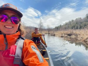 Back in the beginning, our founders considered the best way to get from Lake Champlain to Lake Memphremagog in a paddle craft. There was considerable debate: the Missisquoi or the Lamoille? Donny Mullen, the first person to ground test the entire trail back in 2000, went up the Lamoille rather than the Missisquoi. In the years that followed a number of factors led the team to choose the Missisquoi as the official route. However, I have been wondering about the connection between the Lamoille and Lake Memphremagog for years. With the Canada US border closed, the pandemic has pushed me to finally scout it out.
On April 6, 2021 I met Russ Ford in Albany, Vermont to set a shuttle and scout out the reality on the
Back in the beginning, our founders considered the best way to get from Lake Champlain to Lake Memphremagog in a paddle craft. There was considerable debate: the Missisquoi or the Lamoille? Donny Mullen, the first person to ground test the entire trail back in 2000, went up the Lamoille rather than the Missisquoi. In the years that followed a number of factors led the team to choose the Missisquoi as the official route. However, I have been wondering about the connection between the Lamoille and Lake Memphremagog for years. With the Canada US border closed, the pandemic has pushed me to finally scout it out.
On April 6, 2021 I met Russ Ford in Albany, Vermont to set a shuttle and scout out the reality on the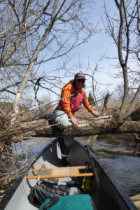 ground to connect the Lamoille River in Hardwick with the Black River in Craftsbury. Hardwick lake, Little Elligo Pond and Lake Elligo are connected by several miles of swamp between the Lamoille and Black River watersheds.
From what we saw, I believe there is no enjoyable alternative to portaging the “river” segments from the northern end of Hardwick Lake to the Black River at Cemetery Road in Craftsbury. We were there at the height of spring melt - there was still enough ice on Lake Elligo to prevent us from paddling it. We put on at the outflow of Lake Elligo on South Craftsbury Road, but it was a tight, windy alder-infested route that will not be there at lower water. The total distance on VT Route 14 would be 5 miles if you paddle the Elligos.
Starting at Cemetery Road, the Black is a beautiful meandering river. We took about two and half hours to paddle to Wylie Hill Road in Albany. We traveled 9 miles on the water, with an elevation loss of
ground to connect the Lamoille River in Hardwick with the Black River in Craftsbury. Hardwick lake, Little Elligo Pond and Lake Elligo are connected by several miles of swamp between the Lamoille and Black River watersheds.
From what we saw, I believe there is no enjoyable alternative to portaging the “river” segments from the northern end of Hardwick Lake to the Black River at Cemetery Road in Craftsbury. We were there at the height of spring melt - there was still enough ice on Lake Elligo to prevent us from paddling it. We put on at the outflow of Lake Elligo on South Craftsbury Road, but it was a tight, windy alder-infested route that will not be there at lower water. The total distance on VT Route 14 would be 5 miles if you paddle the Elligos.
Starting at Cemetery Road, the Black is a beautiful meandering river. We took about two and half hours to paddle to Wylie Hill Road in Albany. We traveled 9 miles on the water, with an elevation loss of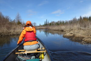 23 feet (or about 2.2 feet per mile). We didn’t come across any rapids, but there was a tree down that we had to crawl over and another we portaged around. The beavers are clearly in charge of this watershed, but we only had to cross one sizable dam after Cemetery Road.
The wildlife gave us a show on a sunny but cool afternoon. Right away we saw a red tailed hawk hunting above us. We came upon a pair of otters frisking about in a pool, so engrossed in their courtship that they were completely undisturbed by our passing. We saw and heard a large flock of evening grosbeaks chattering loudly in a stand of cedar trees. Finally, we heard wood ducks calling to each other further down in the watershed, and two pairs flew out of a stand of cottonwoods displaying their beautiful black and red markings.
23 feet (or about 2.2 feet per mile). We didn’t come across any rapids, but there was a tree down that we had to crawl over and another we portaged around. The beavers are clearly in charge of this watershed, but we only had to cross one sizable dam after Cemetery Road.
The wildlife gave us a show on a sunny but cool afternoon. Right away we saw a red tailed hawk hunting above us. We came upon a pair of otters frisking about in a pool, so engrossed in their courtship that they were completely undisturbed by our passing. We saw and heard a large flock of evening grosbeaks chattering loudly in a stand of cedar trees. Finally, we heard wood ducks calling to each other further down in the watershed, and two pairs flew out of a stand of cottonwoods displaying their beautiful black and red markings. 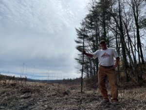 Perhaps the wildest sighting was of a friendly local on the riverbank. He waved, and we stopped to chat. We remarked on the beautiful valley, and he said that he had moved there in the mid-80’s to enjoy the quiet and the scenery. He told us of how the valley had changed over 35 years and who had come and gone. By and by, it came out that we were talking to none other than Bill “Spaceman” Lee of Red Socks Fame and who had once run for governor of Vermont. If you run into him on your trip, tell him we say “Hi”!
Further Down the River:
I haven’t seen the river from Wiley Hill Road to Irasburg, but Russ paddled from Wylie Farm Rd in Albany to the Rt 58/ 14 bridge in Irasburg on May 8, 2021. That was 16.8 miles measured as a track on his GPS, rather more than the distance the AMC guide lists. It is an extremely winding river. There are no dams, falls, whitewater, or hazards other than a few sweepers and downed trees. It is entirely low gradient.
In the village of Irasburg below the Rt 58 bridge (and just upstream from the Mill Street bridge) there are the remains of a mill dam. Further down, a bit before Covered Bridge Rd there is a pretty good ledge. Russ recommends scouting below the 58 bridge at all water levels. Scout or carry (0.9 miles) along Under-The-Hill Rd, river left, from the Rt 58 bridge, continuing across the river on a closed-to-traffic cement bridge, and putting in down a steep bank at the intersection of the subsequent gravel track with Rt 58, or slightly further putting in from Covered Bridge Road. This carry avoids paddling a continuous boulder field plus a couple of ledges. He reports that he has never seen it at a water level that he'd want to paddle in a loaded tandem canoe.
Below Irasburg
Last summer, the NFCT mapping crew gathered and published a couple of resources for the lower sections of the Black.
Perhaps the wildest sighting was of a friendly local on the riverbank. He waved, and we stopped to chat. We remarked on the beautiful valley, and he said that he had moved there in the mid-80’s to enjoy the quiet and the scenery. He told us of how the valley had changed over 35 years and who had come and gone. By and by, it came out that we were talking to none other than Bill “Spaceman” Lee of Red Socks Fame and who had once run for governor of Vermont. If you run into him on your trip, tell him we say “Hi”!
Further Down the River:
I haven’t seen the river from Wiley Hill Road to Irasburg, but Russ paddled from Wylie Farm Rd in Albany to the Rt 58/ 14 bridge in Irasburg on May 8, 2021. That was 16.8 miles measured as a track on his GPS, rather more than the distance the AMC guide lists. It is an extremely winding river. There are no dams, falls, whitewater, or hazards other than a few sweepers and downed trees. It is entirely low gradient.
In the village of Irasburg below the Rt 58 bridge (and just upstream from the Mill Street bridge) there are the remains of a mill dam. Further down, a bit before Covered Bridge Rd there is a pretty good ledge. Russ recommends scouting below the 58 bridge at all water levels. Scout or carry (0.9 miles) along Under-The-Hill Rd, river left, from the Rt 58 bridge, continuing across the river on a closed-to-traffic cement bridge, and putting in down a steep bank at the intersection of the subsequent gravel track with Rt 58, or slightly further putting in from Covered Bridge Road. This carry avoids paddling a continuous boulder field plus a couple of ledges. He reports that he has never seen it at a water level that he'd want to paddle in a loaded tandem canoe.
Below Irasburg
Last summer, the NFCT mapping crew gathered and published a couple of resources for the lower sections of the Black.
- Preliminary maps of the connection between the Lamoille and the Black river watersheds - these are not navigational maps
- Description and link to Map of Black from Irasburg to Coventry
- Description and link to map of Black from Coventry to Newport
North Branch Dead River
 The North Branch Dead River flows from the beautiful Chain of Ponds, near the Canadian border, south 25 miles to Flagstaff Lake. Its mix of lakes, flatwater, and rapids provide variety, and due to several access points, the river can be done as either a 2-3 day trip or as a series of day paddles. While its rapids are generally too low to paddle after mid June, most can be portaged or lined at low water. The river contains an interesting piece of American history. In 1775, Benedict Arnold and around 1,000 men paddled up the North Branch and the Chain of Ponds on their way to attack Quebec. For the modern paddler, the river offers wonderful views of mountains and forests, peaceful sections, as well excellent rapids for experienced paddlers.
Whitewater enthusiasts will love the rapids between Airport Road and the King and Bartlett Bridge, best navigated in the spring. For those seeking a mellow day trip, a paddle downstream of the King and Barlett into Flagstaff Lake provides stunning views of the Bigelows. A weekend trip starting at the Chain of Lakes is hard to beat. Set up a basecamp at one of the free, first come first serve campsites along the lakes, or continue on downstream to explore what the river has to offer.
Downloadable Map
The North Branch Dead River flows from the beautiful Chain of Ponds, near the Canadian border, south 25 miles to Flagstaff Lake. Its mix of lakes, flatwater, and rapids provide variety, and due to several access points, the river can be done as either a 2-3 day trip or as a series of day paddles. While its rapids are generally too low to paddle after mid June, most can be portaged or lined at low water. The river contains an interesting piece of American history. In 1775, Benedict Arnold and around 1,000 men paddled up the North Branch and the Chain of Ponds on their way to attack Quebec. For the modern paddler, the river offers wonderful views of mountains and forests, peaceful sections, as well excellent rapids for experienced paddlers.
Whitewater enthusiasts will love the rapids between Airport Road and the King and Bartlett Bridge, best navigated in the spring. For those seeking a mellow day trip, a paddle downstream of the King and Barlett into Flagstaff Lake provides stunning views of the Bigelows. A weekend trip starting at the Chain of Lakes is hard to beat. Set up a basecamp at one of the free, first come first serve campsites along the lakes, or continue on downstream to explore what the river has to offer.
Downloadable Map
Lower Magalloway River
 The lower section of the Magalloway River, below the dam at Aziscohos Lake, offers a variety of paddling experiences. I
t's upper reaches provide exciting class III rapids during summer release dates. The lower part of the river runs through the Umbagog National Wildlife Refuge, making it great for viewing wildlife such as moose, bald eagles, and the American woodcock. For a day trip, launch at Wilson Mills and paddle south to a launch provided by the Umbagog Wildlife Refuge. For those seeking an easy overnight trip, there are campsites along the river and in Umbagog Lake available via advanced reservation.
Downloadable Map
Aziscohos Dam Release Schedule: https://www.safewaters.com/facility/14
The lower section of the Magalloway River, below the dam at Aziscohos Lake, offers a variety of paddling experiences. I
t's upper reaches provide exciting class III rapids during summer release dates. The lower part of the river runs through the Umbagog National Wildlife Refuge, making it great for viewing wildlife such as moose, bald eagles, and the American woodcock. For a day trip, launch at Wilson Mills and paddle south to a launch provided by the Umbagog Wildlife Refuge. For those seeking an easy overnight trip, there are campsites along the river and in Umbagog Lake available via advanced reservation.
Downloadable Map
Aziscohos Dam Release Schedule: https://www.safewaters.com/facility/14
Connecticut River
Bordered by agricultural fields, the wide and gentle Connecticut River offers a leisurely float along its sandy turns with plenty of places to stop for a picnic and a swim. Several short Class I–II rapids at the start lead to a slow, placid river.
Read full descriptionTrip Reports
Current river conditions
Upper Ammonoosuc Overnight
Good beginner water with the potential to add a mile of rapids at the end of the trip
A nice overnight or day trip
Meander your way through lush riparian forest as you paddle approximately 10 miles on the Upper Ammonoosuc River. This is the perfect stretch to go on your first paddle trip overnight or to test out gear before heading out on a longer expedition. The river is typically slow moving until you get closer to the town of Stark, NH. Between the take-out in Stark and the white covered bridge is a fun stretch of class II water when the river is up. You can scout most of the stretch from the Route 110 roadside. To accomplish this trip we recommend putting in at Ray's Corner Country Store in Milan, NH. Cordwell Campsite is only 2 miles from the Ray's Corner Country Store access so plan accordingly. The next day you will have an 8 mile paddle to the take-out where the NFCT Stewardship Crew recently installed a very user-friendly river access ramp.
Flagstaff Lake
Nice family trip, large lake with the option of river paddling
Ample campsites available for use, 2-3 day trip
Just beyond the peak of Sugarloaf Mountain lies a magnificent valley to be discovered. Historic Flagstaff Lake, at nearly 30 miles long, wraps neatly around the base of the striking Bigelow Mountain Range. Paddling includes shallow seasonal water, marshes and flat water, and amazing views of the mountains. All seven of the Bigelow summits are part of a 36,000-acre public reserve, and two of them are on the list of 4,000-footers in Maine, making them sought after by “peak-baggers.” The town of Eustis and village of Stratton offer a variety of lodging options and some great dining choices - hearty home-cooked meals, fresh sandwiches, and café lunches. Local stores stock essential provisions from fine wine to peanut butter. One of the most unique stories in Maine history, the town of Flagstaff was established in 1775 by Benedict Arnold's forces on their way to Quebec…and 175 years later it was flooded to make way for hydroelectricity production. Check out the Valley Below map showing locations of underwater village landmarks. Learn this fascinating history on a unique pontoon boat tour with Flagstaff Scenic Boat Tours. Stock up ahead of time with sandwiches, produce, beverage and snacks at Fotter’s Market in Stratton. Or choose a boat tour option with a lunch stop at the lovely, remote Flagstaff Hut. In the afternoon, visit the Dead River Area Historical Society and see displays including memorabilia of the very towns you floated over this morning. Paddlers looking to explore the lake can do so with a daytrip or overnight camping trip. There are many sites available on the lake. The trip length is listed below at 5 miles, but since this is a lake trip it can be just about any distance you want.
Island Pond and the Upper Clyde River
In Vermont’s Northeast Kingdom lies the village - and the lake - of Island Pond. Island Pond also serves as the headwaters for the Clyde River, which flows 40 miles northwest to Lake Memphremagog. The area is rich in wildlife and is known for its abundant and diverse fisheries hosting trout, salmon, bass, and many other species. Island Pond and environs is a great destination for fisherman and paddlers in search of off-the-beaten-path lakes and running streams. Put in in the town of Island Pond and take out at either Five Mile Square Road or Route 105 at Ten Mile Square Road access points.
Long Lake to Axton Landing
Nice three-day trip for moderate skill level
Includes 1 mile portage, wilderness characteristics
This trip combines lake and river paddling in the heart of the New York State's Adirondack Park. The trip starts at the state boat launch near the hamlet of Long Lake. From there, paddlers head north toward the Raquette River. Most paddlers choose to spend the first night on the lake, heading into the wild Raquette River on the second day. Long Lake can be choppy, especially at its northern end near the river. The Raquette River is a windy, slow-moving river. The biggest challenge on the river is navigating the 1 mile portage, which includes some hilly terrain. There are numerous campsites available on the lake and Raquette River, including at Raquette Falls, where there is a New York State Department of Environmental Conservation's interior caretaker's cabin.
Missisquoi Wildlife Wonders
Beginner waters downstream of Swanton
Great opportunity to see birds, nice day trip.
The Missisquoi National Wildlife Refuge is just a 45-minute drive from Burlington, Vermont, and it provides a great opportunity for a half-day or full day paddling trip. Known as the “Bird Foot Delta,” the Missisquoi River’s mouth is marked by quiet waters and extensive wetlands. The refuge provides excellent habitat for migratory songbirds, resident mammals and other wildlife, and as such offers some of the finest wildlife viewing in the state. Refuge lands also protect the Shad Island Great Blue Heron rookery, the largest colony in Vermont.
Section 11
Moosehead Lake to Umbazooksus Stream
Museums/Attractions
Penobscot River Paddling Trail
Medway to Verona Island
Museums/Attractions
Connecticut River Paddlers’ Trail
Connecticut Lakes to Long Island Sound
Museums/Attractions
Sandy River
Small Falls to the Kennebec River
Museums/Attractions
North Branch of the Dead River (24 miles)
North Branch of the Dead River
Museums/Attractions
Androscoggin River Trail (Greenway Section)
Livermore Falls to Merrymeeting Bay
Museums/Attractions
Androscoggin River Trail (Mahoosucs)
Gilead to Livermore Falls
Museums/Attractions
Androscoggin River Trail (NorthWoods)
Lake Umbagog to Gilead
Museums/Attractions
Lamoille River Paddlers Trail
Greensboro Bend to Lake Champlain
Museums/Attractions
Section 13
Umsaskis Lake to St. John River
Museums/Attractions
Section 12
Umbazooksus Stream to Umsaskis Lake
Museums/Attractions
Section 1
Fulton Chain of Lakes to Long Lake
Museums/Attractions
Section 10
Spencer Stream to Moosehead Lake
Museums/Attractions
Section 9
Rangeley Lake to Spencer Stream
Museums/Attractions
Section 8
Umbagog Lake to Rangeley Lake
Museums/Attractions
Section 7
Connecticut River to Umbagog Lake
Museums/Attractions
Section 6
Lake Memphremagog to Connecticut River
Museums/Attractions
Section 5
Missisquoi River to Lake Memphremagog
Museums/Attractions
Section 4
Lake Champlain and Missisquoi River
Museums/Attractions
Section 3
Saranac River to Lake Champlain
Museums/Attractions
Section 2
Long Lake to Saranac River
Museums/Attractions
Locations
My Trip
Section 11
Moosehead Lake to Umbazooksus Stream
Museums/Attractions
Penobscot River Paddling Trail
Medway to Verona Island
Museums/Attractions
Connecticut River Paddlers’ Trail
Connecticut Lakes to Long Island Sound
Museums/Attractions
Sandy River
Small Falls to the Kennebec River
Museums/Attractions
North Branch of the Dead River (24 miles)
North Branch of the Dead River
Museums/Attractions
Androscoggin River Trail (Greenway Section)
Livermore Falls to Merrymeeting Bay
Museums/Attractions
Androscoggin River Trail (Mahoosucs)
Gilead to Livermore Falls
Museums/Attractions
Androscoggin River Trail (NorthWoods)
Lake Umbagog to Gilead
Museums/Attractions
Lamoille River Paddlers Trail
Greensboro Bend to Lake Champlain
Museums/Attractions
Section 13
Umsaskis Lake to St. John River
Museums/Attractions
Section 12
Umbazooksus Stream to Umsaskis Lake
Museums/Attractions
Section 1
Fulton Chain of Lakes to Long Lake
Museums/Attractions
Section 10
Spencer Stream to Moosehead Lake
Museums/Attractions
Section 9
Rangeley Lake to Spencer Stream
Museums/Attractions
Section 8
Umbagog Lake to Rangeley Lake
Museums/Attractions
Section 7
Connecticut River to Umbagog Lake
Museums/Attractions
Section 6
Lake Memphremagog to Connecticut River
Museums/Attractions
Section 5
Missisquoi River to Lake Memphremagog
Museums/Attractions
Section 4
Lake Champlain and Missisquoi River
Museums/Attractions
Section 3
Saranac River to Lake Champlain
Museums/Attractions
Section 2
Long Lake to Saranac River
Museums/Attractions
Map Sections
11
00
00
20
21
00
00
00
14
13
12
01
10
09
08
07
06
05
04
03
02
Map Info
Using the Trip Planner
To load trail featuresm click on the “Add Locations” icon in the vertical menu to see the locations icons displayed. You will need to zoom in past the map extent rectangles, which represent NFCT waterproof map extents). You can click on point icons and portages to to learn more.
Building Your Own Trip
To add items to your trip, simply click the “Add to Trip” button located at the bottom of the locations pop-up boxes. All information in the pop-ups will be transferred to your trip itinerary found in the “My Trip” tab located in the vertical menu.
Pre-packaged Itineraries
If you are looking for a recommended trip you can click on the “Itineraries” tab. Here you will find a variety of loadable trips. The trips are designated as day paddles, weekend trips, or longer durations. We also describe these trips by level of difficulty. Click load and the trip will be displayed on the map, zoom in for details. If you like what you see, hit the print button. To start building a new trip just hit the “Reset” button.
If you find this tool helpful please consider making a donation. It is quick and easy, just click the “Donate” button in the upper right-hand corner.
Itineraries
The Black River Connection
Back in the beginning, our founders considered the best way to get from Lake Champlain to Lake Memphremagog in a paddle craft. There was considerable debate: the Missisquoi or the Lamoille? Donny Mullen, the first person to ground test the entire trail back in 2000, went up the Lamoille rather than the Missisquoi. In the years that followed a number of factors led the team to choose the Missisquoi as the official route. However, I have been wondering about the connection between the Lamoille and Lake Memphremagog for years. With the Canada US border closed, the pandemic has pushed me to finally scout it out.
On April 6, 2021 I met Russ Ford in Albany, Vermont to set a shuttle and scout out the reality on the ground to connect the Lamoille River in Hardwick with the Black River in Craftsbury. Hardwick lake, Little Elligo Pond and Lake Elligo are connected by several miles of swamp between the Lamoille and Black River watersheds.
From what we saw, I believe there is no enjoyable alternative to portaging the “river” segments from the northern end of Hardwick Lake to the Black River at Cemetery Road in Craftsbury. We were there at the height of spring melt - there was still enough ice on Lake Elligo to prevent us from paddling it. We put on at the outflow of Lake Elligo on South Craftsbury Road, but it was a tight, windy alder-infested route that will not be there at lower water. The total distance on VT Route 14 would be 5 miles if you paddle the Elligos.
Starting at Cemetery Road, the Black is a beautiful meandering river. We took about two and half hours to paddle to Wylie Hill Road in Albany. We traveled 9 miles on the water, with an elevation loss of 23 feet (or about 2.2 feet per mile). We didn’t come across any rapids, but there was a tree down that we had to crawl over and another we portaged around. The beavers are clearly in charge of this watershed, but we only had to cross one sizable dam after Cemetery Road.
The wildlife gave us a show on a sunny but cool afternoon. Right away we saw a red tailed hawk hunting above us. We came upon a pair of otters frisking about in a pool, so engrossed in their courtship that they were completely undisturbed by our passing. We saw and heard a large flock of evening grosbeaks chattering loudly in a stand of cedar trees. Finally, we heard wood ducks calling to each other further down in the watershed, and two pairs flew out of a stand of cottonwoods displaying their beautiful black and red markings.
Perhaps the wildest sighting was of a friendly local on the riverbank. He waved, and we stopped to chat. We remarked on the beautiful valley, and he said that he had moved there in the mid-80’s to enjoy the quiet and the scenery. He told us of how the valley had changed over 35 years and who had come and gone. By and by, it came out that we were talking to none other than Bill “Spaceman” Lee of Red Socks Fame and who had once run for governor of Vermont. If you run into him on your trip, tell him we say “Hi”!
Further Down the River:
I haven’t seen the river from Wiley Hill Road to Irasburg, but Russ paddled from Wylie Farm Rd in Albany to the Rt 58/ 14 bridge in Irasburg on May 8, 2021. That was 16.8 miles measured as a track on his GPS, rather more than the distance the AMC guide lists. It is an extremely winding river. There are no dams, falls, whitewater, or hazards other than a few sweepers and downed trees. It is entirely low gradient.
In the village of Irasburg below the Rt 58 bridge (and just upstream from the Mill Street bridge) there are the remains of a mill dam. Further down, a bit before Covered Bridge Rd there is a pretty good ledge. Russ recommends scouting below the 58 bridge at all water levels. Scout or carry (0.9 miles) along Under-The-Hill Rd, river left, from the Rt 58 bridge, continuing across the river on a closed-to-traffic cement bridge, and putting in down a steep bank at the intersection of the subsequent gravel track with Rt 58, or slightly further putting in from Covered Bridge Road. This carry avoids paddling a continuous boulder field plus a couple of ledges. He reports that he has never seen it at a water level that he'd want to paddle in a loaded tandem canoe.
Below Irasburg
Last summer, the NFCT mapping crew gathered and published a couple of resources for the lower sections of the Black.
- Preliminary maps of the connection between the Lamoille and the Black river watersheds - these are not navigational maps
- Description and link to Map of Black from Irasburg to Coventry
- Description and link to map of Black from Coventry to Newport
North Branch Dead River
The North Branch Dead River flows from the beautiful Chain of Ponds, near the Canadian border, south 25 miles to Flagstaff Lake. Its mix of lakes, flatwater, and rapids provide variety, and due to several access points, the river can be done as either a 2-3 day trip or as a series of day paddles. While its rapids are generally too low to paddle after mid June, most can be portaged or lined at low water. The river contains an interesting piece of American history. In 1775, Benedict Arnold and around 1,000 men paddled up the North Branch and the Chain of Ponds on their way to attack Quebec. For the modern paddler, the river offers wonderful views of mountains and forests, peaceful sections, as well excellent rapids for experienced paddlers.
Whitewater enthusiasts will love the rapids between Airport Road and the King and Bartlett Bridge, best navigated in the spring. For those seeking a mellow day trip, a paddle downstream of the King and Barlett into Flagstaff Lake provides stunning views of the Bigelows. A weekend trip starting at the Chain of Lakes is hard to beat. Set up a basecamp at one of the free, first come first serve campsites along the lakes, or continue on downstream to explore what the river has to offer.
Downloadable Map
Lower Magalloway River
The lower section of the Magalloway River, below the dam at Aziscohos Lake, offers a variety of paddling experiences. I
t's upper reaches provide exciting class III rapids during summer release dates. The lower part of the river runs through the Umbagog National Wildlife Refuge, making it great for viewing wildlife such as moose, bald eagles, and the American woodcock. For a day trip, launch at Wilson Mills and paddle south to a launch provided by the Umbagog Wildlife Refuge. For those seeking an easy overnight trip, there are campsites along the river and in Umbagog Lake available via advanced reservation.
Downloadable Map
Aziscohos Dam Release Schedule: https://www.safewaters.com/facility/14
Connecticut River
Bordered by agricultural fields, the wide and gentle Connecticut River offers a leisurely float along its sandy turns with plenty of places to stop for a picnic and a swim. Several short Class I–II rapids at the start lead to a slow, placid river.
Read full descriptionTrip Reports
Current river conditions
Upper Ammonoosuc Overnight
Good beginner water with the potential to add a mile of rapids at the end of the trip
A nice overnight or day trip
Meander your way through lush riparian forest as you paddle approximately 10 miles on the Upper Ammonoosuc River. This is the perfect stretch to go on your first paddle trip overnight or to test out gear before heading out on a longer expedition. The river is typically slow moving until you get closer to the town of Stark, NH. Between the take-out in Stark and the white covered bridge is a fun stretch of class II water when the river is up. You can scout most of the stretch from the Route 110 roadside. To accomplish this trip we recommend putting in at Ray's Corner Country Store in Milan, NH. Cordwell Campsite is only 2 miles from the Ray's Corner Country Store access so plan accordingly. The next day you will have an 8 mile paddle to the take-out where the NFCT Stewardship Crew recently installed a very user-friendly river access ramp.
Flagstaff Lake
Nice family trip, large lake with the option of river paddling
Ample campsites available for use, 2-3 day trip
Just beyond the peak of Sugarloaf Mountain lies a magnificent valley to be discovered. Historic Flagstaff Lake, at nearly 30 miles long, wraps neatly around the base of the striking Bigelow Mountain Range. Paddling includes shallow seasonal water, marshes and flat water, and amazing views of the mountains. All seven of the Bigelow summits are part of a 36,000-acre public reserve, and two of them are on the list of 4,000-footers in Maine, making them sought after by “peak-baggers.” The town of Eustis and village of Stratton offer a variety of lodging options and some great dining choices - hearty home-cooked meals, fresh sandwiches, and café lunches. Local stores stock essential provisions from fine wine to peanut butter. One of the most unique stories in Maine history, the town of Flagstaff was established in 1775 by Benedict Arnold's forces on their way to Quebec…and 175 years later it was flooded to make way for hydroelectricity production. Check out the Valley Below map showing locations of underwater village landmarks. Learn this fascinating history on a unique pontoon boat tour with Flagstaff Scenic Boat Tours. Stock up ahead of time with sandwiches, produce, beverage and snacks at Fotter’s Market in Stratton. Or choose a boat tour option with a lunch stop at the lovely, remote Flagstaff Hut. In the afternoon, visit the Dead River Area Historical Society and see displays including memorabilia of the very towns you floated over this morning. Paddlers looking to explore the lake can do so with a daytrip or overnight camping trip. There are many sites available on the lake. The trip length is listed below at 5 miles, but since this is a lake trip it can be just about any distance you want.
Island Pond and the Upper Clyde River
In Vermont’s Northeast Kingdom lies the village - and the lake - of Island Pond. Island Pond also serves as the headwaters for the Clyde River, which flows 40 miles northwest to Lake Memphremagog. The area is rich in wildlife and is known for its abundant and diverse fisheries hosting trout, salmon, bass, and many other species. Island Pond and environs is a great destination for fisherman and paddlers in search of off-the-beaten-path lakes and running streams. Put in in the town of Island Pond and take out at either Five Mile Square Road or Route 105 at Ten Mile Square Road access points.
Long Lake to Axton Landing
Nice three-day trip for moderate skill level
Includes 1 mile portage, wilderness characteristics
This trip combines lake and river paddling in the heart of the New York State's Adirondack Park. The trip starts at the state boat launch near the hamlet of Long Lake. From there, paddlers head north toward the Raquette River. Most paddlers choose to spend the first night on the lake, heading into the wild Raquette River on the second day. Long Lake can be choppy, especially at its northern end near the river. The Raquette River is a windy, slow-moving river. The biggest challenge on the river is navigating the 1 mile portage, which includes some hilly terrain. There are numerous campsites available on the lake and Raquette River, including at Raquette Falls, where there is a New York State Department of Environmental Conservation's interior caretaker's cabin.
Missisquoi Wildlife Wonders
Beginner waters downstream of Swanton
Great opportunity to see birds, nice day trip.
The Missisquoi National Wildlife Refuge is just a 45-minute drive from Burlington, Vermont, and it provides a great opportunity for a half-day or full day paddling trip. Known as the “Bird Foot Delta,” the Missisquoi River’s mouth is marked by quiet waters and extensive wetlands. The refuge provides excellent habitat for migratory songbirds, resident mammals and other wildlife, and as such offers some of the finest wildlife viewing in the state. Refuge lands also protect the Shad Island Great Blue Heron rookery, the largest colony in Vermont.
Section 11
Moosehead Lake to Umbazooksus Stream
Museums/Attractions
Penobscot River Paddling Trail
Medway to Verona Island
Museums/Attractions
Connecticut River Paddlers’ Trail
Connecticut Lakes to Long Island Sound
Museums/Attractions
Sandy River
Small Falls to the Kennebec River
Museums/Attractions
North Branch of the Dead River (24 miles)
North Branch of the Dead River
Museums/Attractions
Androscoggin River Trail (Greenway Section)
Livermore Falls to Merrymeeting Bay
Museums/Attractions
Androscoggin River Trail (Mahoosucs)
Gilead to Livermore Falls
Museums/Attractions
Androscoggin River Trail (NorthWoods)
Lake Umbagog to Gilead
Museums/Attractions
Lamoille River Paddlers Trail
Greensboro Bend to Lake Champlain
Museums/Attractions
Section 13
Umsaskis Lake to St. John River
Museums/Attractions
Section 12
Umbazooksus Stream to Umsaskis Lake
Museums/Attractions
Section 1
Fulton Chain of Lakes to Long Lake
Museums/Attractions
Section 10
Spencer Stream to Moosehead Lake
Museums/Attractions
Section 9
Rangeley Lake to Spencer Stream
Museums/Attractions
Section 8
Umbagog Lake to Rangeley Lake
Museums/Attractions
Section 7
Connecticut River to Umbagog Lake
Museums/Attractions
Section 6
Lake Memphremagog to Connecticut River
Museums/Attractions
Section 5
Missisquoi River to Lake Memphremagog
Museums/Attractions
Section 4
Lake Champlain and Missisquoi River
Museums/Attractions
Section 3
Saranac River to Lake Champlain
Museums/Attractions
Section 2
Long Lake to Saranac River
Museums/Attractions


Trip Itinerary List
Your Trip
The trail features listed below can be paired with NFCT paper maps to plan your adventure. Locations shown on the interactive map may not be survey accurate. We recommend using multiple trip planning sources and on-the-ground caution. Local guides and outfitters can be invaluable. Campsites and access points may have unique rules and/or fees. Report any errors you find to [email protected] to help us ensure we are providing the most up to date information to the public.
The information provided below can be paired with water resistant NFCT maps and guidebooks to provide you with trip enhancing details. Please access other trip planning support at www.northernforestcanoetrail.org. Latitude and longitude information is close approximation, not all features have been field verified. Be safe and use caution. The NFCT recommends using a life jacket when on the water, practicing Leave No Trace Principals, and using the Clean-Drain-Dry process to keep from spreading aquatic invasives.