Trail Overview
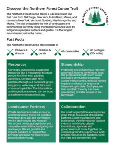
Completed in 2006, the Northern Forest Canoe Trail is a 700-mile water trail from Old Forge, New York to Fort Kent, Maine, that goes through private and public lands. The trail follows traditional travel routes used by Native American, settlers and guides. It is the longest inland water trail in the nation.
It consists of the following:
- 23 rivers and streams
- 59 lakes and ponds
- 45 communities
- 65 portages (70+ miles)
On the NFCT, opportunities for paddlers are endless and services are easy to find. You can camp in an Adirondack Lean-to and paddle through the High Peaks Wilderness, watch moose from the deep woods of Maine, or run whitewater trips down the Androscoggin River in New Hampshire.
To make your planning as easy as possible, NFCT offers maps, books, and an online Trip Planner to help you pick your paddling route and connect you to local services. Explore the trail in google earth by downloading this file. Find a day trip, weekend getaway, week-long vacation or paddle end-to end for a month or more. You can rent or buy equipment from experienced outfitters or you can hire a guide to take you deep into the wilderness. Accommodations range from primitive campsites to bed-and-breakfasts and historic hotels.
We truly have adventures for a lifetime.
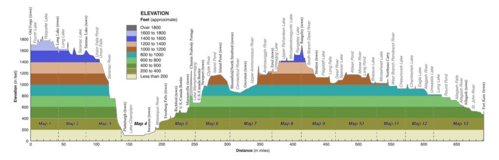
New York
147 Miles
The NFCT runs through the heart of the scenic Adirondack Park. Starting at the NFCT’s western terminus in Old Forge, the trail goes through the Fulton Chain of Lakes on the way to Long Lake and the Raquette River in the High Peaks Wilderness. From there, it crosses the Saranac Chain of Lakes to the Saranac River, where it drops off the Adirondack Plateau into Lake Champlain. Use Maps 1-3 for this section.
Vermont/Québec
174 Miles
Vermont is home to the eastern edge of Lake Champlain, one of the most storied lakes in America and the largest water body on the trail. The Wild & Scenic Upper Missisquoi River flows through farm country and enters Lake Champlain through a delta protected by the Missisquoi National Wildlife Refuge. The “Grand Portage” connects the Missisquoi valley with Lake Memphremagog in Quebec. The Clyde River flows through remote fens, but it also has stretches of whitewater. The Nulhegan River drops through the Silvio O. Conte Fish & Wildlife Refuge on its descent to the Connecticut River valley. Use Maps 4 – 5 – 6 for Vermont, Quebec, and part of New Hampshire.
New Hampshire
72 Miles
New Hampshire is home to three of NFCT’s rivers: Connecticut, Ammonoosuc, and Androscoggin. The
The Connecticut offers a nice ride on swiftwater as it meanders through a broad valley to the Upper Ammonoosuc River. In this section, the Northern Forest Canoe Trail is also part of the Connecticut River Paddlers’ Trail. The Upper Ammonoosuc is a fairly slow-flowing river with a few rapids. The Androscoggin is wide and swift with long sections of whitewater here. The river section is part of the Androscoggin Canoe Trail. Use Maps 6 and 7 for New Hampshire.
Maine
347 Miles
Maine contains more miles of NFCT waters than any other state or province on the trail. The Rangeley Lakes are large and surrounded by conserved forests and mountains. The South Branch of the Dead River provides a whitewater run when it has enough water to be paddled. Flagstaff Lake spreads out beneath the dramatic ridgeline of the Bigelow Range. The Dead River is placid until it tumbles over Grand Falls. Spencer Lake and Stream are remote and scenic. The Moose River flows through many lakes and ponds as it meanders to Moosehead Lake, which is the largest in Maine and part of the Thoreau Wabanaki Trail. The West Branch of the Penobscot is wide and slow and ends in the open stretches of Chesuncook Lake. The Allagash Wilderness Waterway is a spectacular ribbon of lakes, ponds, rivers and streams winding through northern Maine. The St John River flows through a scenic, international valley to the eastern terminus of the Northern Forest Canoe Trail in Fort Kent. Use maps 8-13 for Maine.