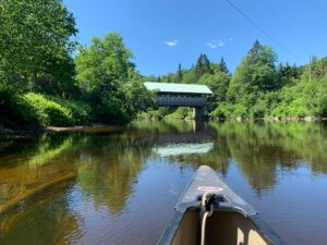
The lower section of the Magalloway River, below the dam at Aziscohos Lake, offers a variety of paddling experiences. I
t’s upper reaches provide exciting class III rapids during summer release dates. The lower part of the river runs through the Umbagog National Wildlife Refuge, making it great for viewing wildlife such as moose, bald eagles, and the American woodcock. For a day trip, launch at Wilson Mills and paddle south to a launch provided by the Umbagog Wildlife Refuge. For those seeking an easy overnight trip, there are campsites along the river and in Umbagog Lake available via advanced reservation.
Aziscohos Dam Release Schedule: https://www.safewaters.com/facility/14
Trip Details
- Trip Duration: 1 to 2 days
- Miles: 20
- Trip Portages: None
- Put In: Aziscohos Dam: Driving on ME 16 north from Errol, there is a turnoff onto a dirt road on the right. The dam is just above this section of the river and this access point puts-in right into a mile-long stretch of continuous Class III rapids. To avoid these rapids, use the Wilsons Mills Access: On ME 16, just past a bridge going over the river, there is a dirt road on the left. This leads down to the river where parking is available on the side. This property is privately owned, but the landowner allows river access as long as it is not abused.
- Take Out: Steamer Diamond Boat Launch: On the right of ME 16 just outside of Errol is a gravel boat ramp that can be used for public access. Or use the Errol Dam Access: Driving into Errol on ME 16, take a left on ME 26. Then drive about 0.2 miles before turning left onto North Mountain Pond Road. Another mile up this road will lead to a public access point with a boat ramp.
-
Services:
- Lower Magalloway River
- Trail Features