Micah Fay is a one-time wilderness dweller turned urban software engineer, by way of carpentry, solar installations, home energy auditing, telecommunications/IT work and some nonprofit startup experience. You can read about his time living off the land in British Columbia in the book Becoming Wild by Nikki Van Schyndel. To see a full gallery of photos and videos from Micah’s trip, click here.
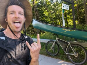
We left West Philly a few hours later than we planned to. Doing a final audit of my gear took a while, and my friend who joined me for the first day didn’t mind the late start. He went to grab one last thing from his car as I paused in front of my house to take a photo of my loaded bike. He came back with a conch shell, leaned way back, and blew a few long ceremonious notes towards the sky to mark the beginning of the trip. Rituals often hit me harder than I expect them to, and the anxiety of planning last minute details was replaced with calm, excitement for the trails and waterways ahead, and gratitude for being able to take a break from work to do something for myself.
I had been dreaming about paddling the Northern Forest Canoe Trail since I first heard about it. And cycling there on some rail trails and then back south along the newly created Eastern Divide Trail mountain bike route seemed like the perfect way to deal with transportation to and from the canoe trail and for me to finally try out bikepacking.
It was my first cycle tour of any kind and I was looking forward to the simplicity of leaving for a wilderness adventure without having to get into a car. Riding through my neighborhood, not on our way to an adventure, but already on one, felt freeing. We rode the Schuylkill River trail out of the city to Valley Forge Park and stealth-camped in the woods behind Washington’s Headquarters that first night, and I rode it to its end in Hamburg, PA, the following day. Having ridden the Philadelphia sections for much of my life, finally riding the SRT to its end felt like a significant achievement. It also reminded me, despite the larger adventure I was heading out on, how much more there is to explore in my own backyard. From Hamburg, I stitched together some rail trails and quiet country roads through Pennsylvania and New York all the way to Old Forge and the Adirondacks.
I had purchased a canoe, paddle and life jacket over the phone from Mountainman Outfitters in Old Forge, which were waiting for me when I arrived. I grabbed a few other things — a sun hat, a copy of the NFCT guidebook, an extra bear bag for food that wouldn’t fit in my bear can on the longer remote stretches, and a large dry bag that could fit all my gear instead of stringing together all my bike bags on every portage.
I opted not to bring paper maps given how many I’d need for all the places I was heading. Instead relying on NFCT’s FarOut guide, which was so good it felt like cheating. I had never really used GPS during my earlier wilderness experiences, and while I’m proud to be able to navigate with a map and compass, knowing exactly where you are at any time is really nice, and it frees you up to enjoy other things. I brought a handheld GPS/satellite messenger for redundancy in case my phone broke and for emergency communication. It also live-tracked my location so family and friends could follow along online. It became part of some folks’ nightly ritual to see how far I made it that day, which was fun. I never did have any emergencies, but I do recommend bringing something like that on trips away from cell service — for your loved-one’s peace of mind if not your own. They’re pretty affordable these days.
Once I gathered everything I’d need from the shops in Old Forge, I loaded my new canoe up with my gear, a celebratory amount of food, and my bike — which luckily fit inside with only minor disassembly. It was a little after noon on Aug. 24 when I started paddling up the Moose River and onto the Northern Forest Canoe Trail. I paddled hard to get through the first few busy lakes before dark. I wanted to get away from the motor boats so I could have a quiet layover at my first camp of the NFCT, swim, and do some laundry after my sweaty ride north.
The first day of the NFCT also included the first portage, and my first attempt at loading my canoe onto my bike. I had the idea that I could use my bike as portage wheels, with the canoe sitting upright on the handlebars and seat, but like pretty much everything else on this trip I hadn’t had a chance to try it before I left, and the portages would have been really slow if I had to do them all in multiple trips. Luckily, it worked fantastically. Other than space in the boat while paddling, I think a bike is probably superior to the wheels built for the purpose. I was able to tackle a lot of trails that would have been impassable with two wheels side by side, or with less clearance below the boat.
 Getting the canoe onto the bike is more of a trick than a feat of strength. If you’re curious, here’s a clip of me loading it up at Union Falls Pond. The steps are: lay the bike and canoe on their sides, and pull them together so the bottom of the canoe is sitting with its keel centered on top of the handlebars and seat of the bike; then run a loose loop of rope tied to each end of the handlebars and around the top of the canoe; from there, you walk to the top side of the canoe, grab the gunwale near the seat of the bike and the rope near where it runs under the gunwale to the handlebar, and lift as you push towards the bike. You’re all loaded. You just walk along beside it with one hand on the handlebar under the canoe and one on the gunwale to stabilize it. It’s like a steerable pair of canoe wheels with brakes.
I don’t know if anyone had done a #bikeanoe portage before, but I hope it catches on. Lots of folks were asking me about it when I rolled through the towns. They took pics and vids of me, gave me thumbs ups, and shared sometimes expletive-laden appreciation for my set up; all of which I appreciated. Some of the packable canoes and rafts look cool for bike/boat tripping, but I think the frequent shallow waters would have shredded one on this trip, and the extra weight would have made the off-road cycle south difficult. My bike already weighed 90 pounds with all my gear.
The Adirondacks didn’t disappoint. Once past the Fulton Chain, the more dramatic peaks start to come into view across the expansive lakes and around bends in the rivers. The northern half of Long Lake and the subsequent section of the Raquette River are as remote as it gets in the ‘dacks and the long sunny days paddling with the current and swimming in the still warm water were amazing. I think I took a hundred videos of aquatic grasses swaying in the current with the sunlight reflecting off the water’s surface before I gave up on adequately capturing just how mesmerizing the scenes were.
It took me a few days to ramp up to the speeds I’d have to travel to get to Fort Kent before full-on winter; I hadn’t paddled a canoe in over a year. But, by the time I got to the Saranac River I was breaking 20 miles every day and loving every hour of it. I’ve never been particularly strong or fast, but I’ve always been able to keep paddling/walking/cycling for 12 hours a day as long as nothing starts to ache too bad — which, at 40, is becoming more common.
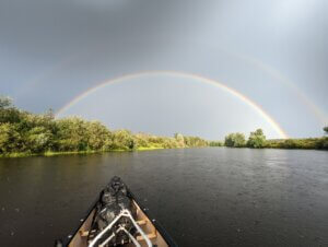
One of the most memorable sections of the trip was crossing Champlain at the bottom of the Saranac. I arrived at the campsite just upstream from Plattsburgh around 3 pm on a windy day. The forecast showed a short break in the wind overnight, followed by four days of 10 mph winds out of the south. That may not sound that bad, but it’s enough to make Champlain impassable in a canoe, and the wind is a lot scarier than the dark in a small boat on open water. So, rather than waiting for the winds to be calm during the daytime, I loaded back up and paddled the rest of the way to Plattsburgh, got dinner and prepared for a long night crossing of Lake Champlain. I called a couple friends while I waited for the wind to die down, partly just to catch up, but also so someone would know what I was about to do in case my little GPS blinker stopped blinking. It ended up being one of the most beautiful and peaceful stretches of the whole trip. I watched the sunset over the Adirondacks as the last of the motorboats went in for the night. The moon and stars came out and shone just bright enough to pop the most subtle silhouette of the mountains against the sky. The wind had stopped completely and the stars reflected off the lake’s surface almost as clearly as they shone above. The whole scene was disorienting in the most beautiful way, and drifting in the lake felt closer and closer to drifting in the cosmos as exhaustion crept in on me. I made it to camp on North Hero at 1:30 am.
 From Champlain I headed upstream across Vermont, Quebec, and New Hampshire to Maine. It was actually the upstream sections that got me interested in the NFCT; the chance to pay homage to the history of our waterways by following old Indigenous trade routes both up and down stream — as all of our rivers were once traveled — drew me in. It also meant I’d have the chance to refresh my canoe poling skills. I had learned to pole a canoe from Master Maine Guide Ray Reitze when studying for previous adventures, and was excited to shake off some of the rust. Once you get the hang of it, poling can feel like a dance either upstream or down. And while a good paddler needs to be able to read the rivers well to pass smoothly downstream, going upstream often requires that ability to make any progress at all. When it’s going right, you feel the pole bend slightly under your weight and snap you forward at the end of the stroke. Trying to stay in the back eddies when you can, whipping into the current to pass rocks and quickly tucking back into the next eddy in front of them is a real joy. When it’s not going right you start wondering how much faster it would be to just walk up the nearest road — a choice I strictly only made for the safety of myself or my boat.
A few of the sections in this stretch required careful walking right up the river beds at the lower water levels. Placing each foot slowly and often blindly on slippery rocks that threatened to twist an ankle made travel slow. But getting those smooth stretches of poling in made it worthwhile. Even the slowest stretches are fun if you accept the pace and enjoy the surroundings. The trail passes through a few more developed areas in Vermont, Quebec, and New Hampshire where the peaceful wilderness is replaced with quaint towns, old mill dams, covered bridges and other historic sites that are interesting in their own right. I didn’t explore the towns I went through as much as I would have liked to. I had a cable lock that I would use to secure my gear when I was shopping, but it would have only slowed down anyone who really wanted to get anything. I didn’t feel unsafe at all, but I’ve lived in places where bike theft is nearly instant in those circumstances, so I tried to be on my way after getting whatever I needed supply-wise. I also never stayed in any hotels, and I’m sure they could have provided secure storage. If I had the trip to do again, and unlimited time and money, I would love to stay a night or two in every town and make sure to camp at least one night on every pond, river, lake, and stream. There is a lot to take in out there, and at my pace I think I missed a good bit of it.
Once I got to Maine, a few days of heavy rain swelled the rivers up nicely for the way downstream. I hunkered down in the Halfway Hilton lean-to in Rangeley for one of those rainy days which was glorious, and one of only a few layovers I took the whole trip. I ran into a crew of AT hikers as I portaged through town which was fun. I think we were both jealous of each other — them for the solitude and water access of the NFCT and me for the camaraderie of having so many other folks on the same trip with them. After a couple nights of relaxing, stops at most of the restaurants in town, a grocery store rotisserie chicken, heaps of junk food, and some fresh fruits and vegetables, I was on my way down the Moose and into the final stretch of the trip.
The remote sections of Maine were of course the cherry on top of the NFCT. I didn’t run into many people during any part of my trip — no one seems to know that September and October are the best months to go camping in the northeast — but the Maine wilderness felt particularly endless.
I bought my last load of food at the grocery store in Jackman. I hadn’t planned any food drops or anything since there are lots of places to resupply along the way; I’m also not much of a planner. This last supply had to last me ten days though, so it was probably 30 pounds of food. I had lost a bit of weight in the earlier cycling/paddling sections and had been steadily increasing my food intake as a result. By the end I was eating four to six thousand calories a day — mostly in the form of peanut butter stirred into everything from oatmeal to instant ramen. That heavy load leaving Jackman made the next few portages pretty rough, but by that time I had the #bikanoe thing down and could still do most of them in one trip despite the load.
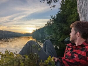
I noticed myself feeling much more present as I got into the second half of the NFCT. It was easy to get preoccupied with the logistics and physicality of the whole thing, especially when racing winter, but once the end was in sight, I started dreading it being over and savored it even more. The final Maine stretch is a good place to be present, and the leaves were close to the peak of their fall colors as I crossed over Moosehead Lake and onto the Penobscot.
A lynx walked along the shore of Lake Churchill with me for about fifteen minutes that felt like forever; peaking at me through the grasses by the edge of the lake and even walking along the rocky shore in plain sight. For an animal that I’ve always thought of as elusive it didn’t seem to mind me being there at all. I actually decided to keep far enough offshore that it couldn’t make the leap into my canoe if it decided to try. Its intentions aside, I felt blessed to spend some time with it.
Later that same day I made the portage into the Allagash Wilderness, which, if paddled on its own, is already the trip of a lifetime. Unfortunately, I had to carry down to Bisonette Bridge because the Churchill Dam outlet was closed and the water was too low to get through the Chase Rapids, which are supposed to be a blast. The water was low from there on out but not so low I had to get out of the boat. Just careful route picking and lots of poling along through the shallows. By the Allagash many of the tall mountain ranges are too far away to be seen on the horizon, but it has its own majesty. I tried to soak in as much of it as I could, and even let myself nap as I drifted with the current for a few long stretches.
I arrived in Fort Kent on Oct. 3 after 40 days of paddling, and on my 40th birthday too! At 25 degrees it was the coldest morning of the trip up to that point. But the blue skies over the Saint John, colorful leaves, glistening frost, expansive rolling farmland, and steady current made for a wonderful birthday and final day on the water.
 I mailed a box home with my dry bag, guidebook, and fishing gear — I had caught two bass the whole trip and probably spent $200 on licenses and lures. As for my canoe, I reached out to several local orgs and posted a listing on Facebook marketplace for best offer or donation. In the end the University of Maine Fort Kent’s adventure program responded first and were a pleasure — would recommend donating a canoe to them. Hot tip: the school cafeteria is open to the public and serves a buffet of many things you will be missing by this point. I went back twice after they bought me lunch the first time. After a couple nights of camping in the park in town — and with a very full belly — I put the racks back on my bike and prepared for the second stage of my journey.
The Eastern Divide Trail mountain bike route enters the US in Houlton, Maine, about 100 miles south of the terminus of the Northern Forest Canoe Trail. From there you can follow it north to Cape Spear, Newfoundland or south to Key West, Florida. It includes some chill gravel roads, some pretty rowdy singletrack for a loaded bike, and everything in between. There’s also a paved road here and there to connect the unpaved sections.
I rode on a nice network of rail trails from Fort Kent to Houlton, with only a few miles on pavement along the way, then headed south towards Key West. Getting back on the bike was both thrilling and jarring. Bouncing and rattling over deeply rutted Maine forest roads, climbing up — then skidding down — loose gravel hills, was quite a contrast from the quiet, steady days paddling a canoe — not to take anything away from the rapids sections of the canoe trail that were also pretty thrilling.
The EDT is brand new — the final sections of it were made public while I was on the NFCT — and that meant I was able to help scout some routes and add a few tips to the planner for future travelers, which was a highlight for me. One of those additions is the NFCT Halfway Hilton in Rangely. The EDT passes down the road behind it, and the folks at the NFCT and the Museum that owns the land are willing to allow bikepackers to use the lean-to as well. I hope some cyclists and canoeists cross paths there in the future, or at least get a chance to learn about the other trip, whichever they are on. They’re both such treasures. I took another glorious rainy day layover there on my way south, and was surprised how cozy it felt to stay in a familiar place after a couple months of constant moving.
Being on a bike afforded me a bit more freedom and the opportunity to visit some friends who weren’t quite on the route, so I took detours off the divide to the Maine Coast and parts of Vermont as I made my way south. Getting to see some dear friends after so much time alone was rejuvenating. I love solitude only almost as much as I love people at the end of the day.
I crossed the NFCT several times on the EDT. It was a treat to catch views of some of the lakes and rivers I had paddled from the ridges of the continental divide. They follow different paths for the most part though, and I loved getting a fuller picture of the northeast by seeing it from both perspectives. The final crossing was near Old Forge, NY, where I had made my first #bikanoe portage to Sixth Lake. I stopped to take a photo there and to just soak up how far I’d traveled in the past couple months.
After dropping out of the Adirondacks, and the steep climbs and descents that characterize the New England portion of the EDT, it heads west over the Finger Lakes, largely on the smooth and level Erie Canalway Trail. I loved the steep sections, but appreciated the chill, historic Erie Canal section as well. I heard from my uncle, who was following my journey online, that my great grandfather had worked the barges there as a youth, which made it even more interesting to pedal, wondering which of the historical sites I was passing he may have worked on. I rode that whole stretch in two 80-mile days. Clear skies made it easy to just roll my sleeping pad out under the stars next to the trail once it got dark and start pedaling before it got light and fitness traffic picked up.
By the time I got around the last of the finger lakes and onto the Genesee Riverway Trail, the days were getting short, and the long nights reading on my kindle were feeling a bit monotonous. I had also started getting some nerve pain in my fingers while riding — a remnant of some old injuries that come back to haunt me occasionally. My cousin told me that your handlebar should be an inch above your seat for every 10 years you are over 30, so I got a stem extension in Canandaigua to see if it would help. It helped some, but the tingling wasn’t going away completely. I started telling myself “Well, I’ll finish this section and see if I’m still having fun.” And I kept on having fun for a long time.
The stretch down through the Genesee Gorge in Letchworth State Park was breathtaking and included some of the more aggressive — and fun — singletrack cycling of the trip. From there the divide goes across a long series of rolling farmland hills through New York State before dropping down into Pine Creek Gorge in Pennsylvania. Much of the Pennsylvania mountains are dominated by long ridges and valleys; the route goes up and down many of them but also has several long rides down the backbones of those ridges. It was well into November at this point so I had clear views through the leafless trees on either side which made this somewhat more tame section of the Appalachian chain pretty memorable. My parents also came out and spent a couple nights with me near State College, PA, which was a lovely break. The Pennsylvania section ends with a ride through the abandoned turnpike tunnel — I recommend riding through it with lights off for maximum eeriness — before a final ridge ride and a drop into Maryland where the route joins the C&O canal. Seeing so many interesting landscapes at a cycling pace was amazing, and being able to easily pop into a town for a morning at a cafe and then be in remote wilderness that night, without getting in a car, was as wonderful as I thought it would be.
My brother Zach planned to meet me in Davis, WV, a mountain town we had both spent time in, to hang out for a weekend before I continued south. We’d rented an Airbnb there for a few nights, and I ended up having to push hard through slushy roads and muddy trails to get there on schedule. The night before I got to Davis I camped in the Dolly Sods, and the winter weather I had been staying just ahead of finally caught up to me.
It was Nov. 17; the temps dropped below 10 degrees, with wind speeds of around 25 mph and 6 inches of fresh snow and ice on the ground. I spent the night curled up in a ball, wearing all the clothing I had with me, and thought about what the next few months would be like if the trails continued to be icy and muddy til I got to Georgia. The nerve pain in my fingers hadn’t improved either, and I was worried that I may be doing permanent damage by continuing to irritate it. I woke up to a gorgeous, crisp, bluebird morning like the day when I got to Fort Kent, made my coffee and peanut butter raisin oatmeal from the inside of my tent, and broke camp. The road around the perimeter of the plateau was covered in snow and ice which groaned at the still frigid temperatures as I rode along it. I stopped for a while at an overlook and watched the rays of the rising sun glistening in the icy branches of the trees from the edge of the plateau. Then, as I descended off the plateau towards Davis, and the wind picked back up, and it started to snow and rain again, I decided to catch a ride back to Philly with my brother.