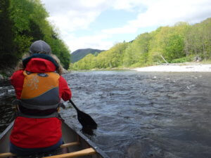
The Sandy River flows east out of western Maine’s mountains for 52 miles before its confluence with the Kennebec, seven miles upstream of the village of Norridgewock. The Sandy provides a diversity of trip experiences for the recreational paddler. Its upper reaches contain exciting but approachable rapids. Put in below Small Falls for an exciting, Class II-III run with several gorges requiring careful scouting, or at the Route 4 bridge for a more easy, but still lively, early spring run to Temple.Those seeking to explore these stretches should plan trips from mid April through May and should be prepared for cold water and continuous rapids.
Lower reaches intersperse pleasant rural paddling with the occasional ledge drop. With the exception of Farmington Falls, the river is runnable all season long, and mellow currents making down and back trips feasible. We recommend a seven mile trip from Farmington to Farmington Falls as a June trip. This day paddle starts out with a ledge drop before the river calms and turns into mostly flatwater around meandering bends. This section features an abundance of wildlife and interesting geological features on the river bank.
Trip Details
-
Services:
- Sandy River
- Trail Features