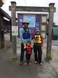
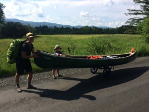
 My husband, Chris, my son, Rewan, and I began section paddling the Northern Forest Canoe Trail in June of 2018, when Rew had just turned 4. We knew we wanted to do a long canoe adventure and Rew had grown up in our boat. Chris and I were well-weathered thru-hikers who met on the Pacific Crest Trail and hiked the Continental Divide Trail for our first official date. After having a child, floating our gear seemed easier than carrying it — diapers and all. So we took to the water. This is the story of how our navigation of the trail evolved.
The first season we planned to paddle Old Forge to Lake Champlain. I am the navigator and felt really confident I could figure out a bomber system as we went, but I have to be honest, I didn’t love the process. I am a bit of a map geek and I found the maps to be challenging as they are written mostly for downstream paddlers — not fools like us. The features and icons are small compared to the overall map and numbered with little messages on the side about that feature. There were lots of tiny icons to look for, like the tiny portage symbol, and I am colorblind, so it can be tricky. What I really needed to know was how not to get stuck in a rapid; we did not want to run with a loaded, open canoe with a kiddo inside. Camping and mileage and put-ins were also important to us. We were also paddling upstream a LOT, so our info was in reverse as the map was written for downstream paddlers. We were also following along looking for actual landmarks river right and left. It made my job a little stressful. Reading two guidebooks alongside the maps would make it challenging as the information did not always match.
The NFCT online trip planner was awesome, but I could not import that information digitally without cellular data and though I spent hours creating trips, I could not print the trip maps from what I could tell. My trip itinerary would print in a list style, but it was hard to figure out how to view this visually with all the icons I put in — campsites, towns, post offices, stores etc. They all printed separately, as in a list of campsites and mileages or a list of the towns I wanted to stop in. Was I missing something? Probably, but we had to head out and I never figured it out.
 Last minute I finally broke down and attempted to create a route on the Gaia App to use in airplane mode. This app is a GPS app that uses the satellite info all phones include for free for location purposes to navigate. Creating a route was nearly impossible because while Gaia offers a “snap to trail” feature, it does not offer a “snap to waterway” feature. So my route was point to point — over 1,000 points, to go around bends in rivers and make turns around islands. I would stare at the NFCT maps and import the trail into Gaia. After a night’s work, it would suddenly “snap” to a road on the bank of the river instead of the trail. This was not a problem in the wilderness, but in places near a road, this happened a lot and was just awful. I would spend all night after putting my child to sleep connecting the dots and then have it jump off the river onto a road nearby. But I wanted the trail to “snap” to a road or trail occasionally on a portage, so I couldn’t turn that feature off — so, SO frustrating. As far as I could tell, I could not find a single person who had uploaded a track (a track is an actual real time recording of your journey while a route is a point to point plan of where you will go) of the entire trail into Gaia. I did my best, but knew I would only use it for large lakes and tricky waterways.
Still, with a basic GPS trail that I could use in Gaia, I felt better. In case I took a wrong turn or was drifting in a large body of water or ended up on an unmarked dirt road looking for a portage route, I knew I could find our location with Gaia offline in airplane mode using minimal battery life. We would use our trusty Anker battery bank which gave us four charges and we kept our phones off except for photos and a bit of navigation check in. This system worked well and by the end of the eight days, we were in love with the NFCT. It is definitely type 2 fun and doing it with a toddler makes it even more interesting, but we grew as paddlers so much by just trying to use our thru-hiker mentality of rolling with it all. We never did take a wrong turn and we made it safely through our beloved Adirondacks to Lake Champlain, and finished our section by running the Saranac with little Rew holding on for dear life, humming.
While navigating on the water, I usually fold the portion of the map I need out and the section of the official NFCT Guidebook and Katina Daanen’s Through-Paddler’s Companion take turns on the backside of my waterproof map case. This gets clipped onto the bow handle. I am reading and paddling and flipping back and forth. Then I am opening it and closing it often to flip pages and taking sections out and trying to memorize them so that I don’t forget something. Then when we are near a tricky section, I am pulling out Gaia on my phone, which is in a waterproof case on my neck, to briefly check that I am aiming for the right landmark, especially on big lakes. It is time consuming, but I am used to this from hiking the CDT, which was similar. Then on breaks I am spending my rest time reading ahead, reading the numbered icons and matching it to info in two books and picking the route or campsite or destination on the fly. I am also looking for info on cool sites, history, geology and wildlife, to make the trip more interesting and educational for our son. We do not have an itinerary before we leave for daily mileage — we get where we get each day doing our best paddling from sunrise to sunset or until an amazing campsite appears. This worked well for us. I point and my husband steers us where I tell him to go with 100% trust after over 5,000 miles of journeying together.
 The second season I knew we would be starting off with the crossing of Lake Champlain and that we would end up near the Fen in Island Pond, VT. I again made my little connected dots with Gaia but I also reached out and was lucky enough to snag a GPX track from Mack Truax (thanks!) to use in Gaia. That helped me a lot. He took a track of himself navigating on one of his thru-paddles and I guessed that he was a conservative paddler because he had a nicer boat than ours! Ours was a beater — a 1980 Old Town Laker 16 named Frieda, and we knew that if he could run a rapid in a nice boat, we could probably do it, too. If it was too low and was scraping his boat, we might be able to keep going and drag ours with minor repercussions for a while, but we often used his put-ins and take outs because we knew they worked. We used his track a lot in the Fen to avoid lots of wrong turns but it also helped me feel safe near un-runnable rapids. Of course, water levels and conditions change daily, so it was just a guide, but it was so nice to have. On this trail, we only met one other thru-paddler in three years, and with no one giving us hints on trail conditions up ahead — as thru-hikers do in trail registers — we were flying blind. Having Mack’s track felt like having a little lighthouse in rough seas.
We made it across Lake Champlain in lovely conditions, up the Missisquoi with our giant 5 gallon water tote because the water is not drinkable, into Canada dragging our boat to the border, back into Vermont at Lake Memphremagog and, after many portages, through the lovely Fen, under the hotel and into Island Pond. A very smooth journey, but again, super challenging with an upstream paddle and lots of dragging and walking Frieda down the road, lightning and downpours, low water levels and rapids to portage. But by now, we felt like we were pretty tough, navigating well and could handle anything the trail threw at us.
We skipped the next summer due to COVID but we were back at it for season 3 in 2021. Before we left at the end of June, I was doing the same annoying thing and trying to create my own route in Gaia when I decided to do a quick google search to see if I could find a GPS track (I lost Mack’s) or if Guthook (now FarOut) had an NFCT app yet. Lo and behold, I came across a post from the NFCT organization and saw that to my surprise, the past two weeks of long nights were a waste because Noah Pollock at the NFCT office was in fact looking for Beta testers for the new Guthook NFCT app! Hello! Me!!!
 I admit I had previously been a Guthook shamer. I had hiked the Triple Crown (the AT, PCT and CDT) before cell phones with paper maps and compass and I was an old school purist. I thought everyone using Guthook to hike one of the longer trails in America was cheating. I thought it was totally unfair to blindly follow a little red line. I was basically a reformed luddite and had just gotten my first cell phone. But then my good friend and avid navigator Renee Patrick of the Oregon Desert Trail Association started to reform my ideals about wilderness navigation.
Renee travels untraveled places in the high desert all the time and alone. She does this with confidence because of phone navigation apps. They have never let her down. She can and does carry and read paper maps, but uses mapping software as an insurance policy in trail-less and wild places. I knew that she thought Guthook was a pretty amazing app. It was also a social app — you could help future adventurers by leaving helpful comments that they could then read years later. It was like a GPS mixed with a trail register! I had broken down and used it to hike the last 120 miles of the Long Trail the summer before and I admit, it made things very easy. How far ‘til water? How much further to the next campsite? Does this town have pizza? I spent more time hiking and less time navigating and reading. I also added helpful comments about water sources, campsites or sketchy situations. So I sent Noah a message and was hooked up with a free Beta account. In exchange, he asked that I check waypoint locations, add helpful info and share photos. It was not a full featured trail app at the time and I was warned that the mileage was not correct, that some of the waypoints were in the wrong spot and that there was not a whole lot of extra info up and running yet, but I was so excited to add all of that as we went.
We started in Island Pond in late June 2021 and made our way slowly but surely to Maine trying to fix waypoints, add portage trails, and add helpful camping, water and town info. A lot of the time I added little messages about water sources, towns, businesses, campsites, rapids and portages up to 15 times per day. While this took a little time and maybe annoyed my family, I knew I was giving back to all the paddlers in years to come. I also felt free to share a few stealth camp sites that might be helpful if the winds were not in your favor on a big lake. I knew that people would appreciate knowing that if WE had to portage, they may also like to portage. I found a few extra easy portage routes and added road walk distances when I could from Google Maps. I really enjoyed writing things that I thought would specifically help future thru-paddlers. It was in NO way comprehensive, but I hope that what we experienced and shared could be helpful to future generations of paddlers.
 I never could figure out how to link a photo to a waypoint, as that feature was not available at the time, but I took a bunch of waypoint photos! I also was able to turn on the tracking feature a few times to track us as we did a portage, then I could add info about that portage like: “you are carrying your boat here — no wheels until THIS point.” Also helpful to thru-paddlers: I entered the hours that restaurants and gas stations and corner stores were open and what they carried, as well as their phone numbers.
Some people might think of the FarOut App as cheating, but that is fine by me. Anything that makes something THIS challenging easier and safer for others to enjoy is welcomed. Not everyone geeks out on maps and has the patience to simultaneously read a map backwards with two guidebooks. We can agree we all love wilderness, paddling and type 2 fun. How you get from point A to point B on a long journey is up to you, but why not use every resource you can to alleviate navigation fatigue and stress? Remember how we all used to drive a car with a map on our lap and a MapQuest printout on our steering wheel? Now we use a GPS for ease of use and safety. Same thing. I truly believe that using the FarOut App will make your thru-paddle more enjoyable and give you a sense of community with those who have gone before you or will come after you. It is a lonely trail now, but there is SO much potential there for this to be a journey many more people take if the resources are top notch.
I am so thankful for the chance to use this app and am really impressed with it. All you have to do is check in and there you are, a little red arrow following a little red line. If you hold your phone flat in your palm and turn your body, it points your little red arrow toward your desired point and you pick a spot on the horizon and paddle on. Take a breath — you are exactly where you want to be.
Peace and happy paddling! You will see us out there on our last leg this year from Flagstaff Lake Dam to Fort Kent! Wish us luck! Our son will be eight, so not the youngest thru-paddler, but he is pretty rad nevertheless.